(NEW YORK) -- A severe weather threat is shifting back to parts of Kansas and Oklahoma on Saturday after damaging winds, hail and tornadoes impacted the region over the past week.
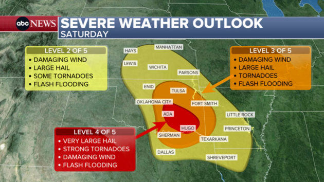
A level 4 of 5 "moderate risk" has been added for southeast Oklahoma, including Ada and McAlester, for the potential for very large hail (larger than baseballs), strong tornadoes, and damaging winds.
A level 3 of 5 "enhanced risk" is up for northeastern Oklahoma and far eastern Arkansas, including Oklahoma City, Tulsa, Broken Bow and Enid, in Oklahoma, and Fort Smith, Arkansas.
Damaging winds and very large hail are the primary threats with these storms, but a few tornadoes, some potentially strong, cannot be ruled out with these storms.
This will be a later day event, with storms not likely to begin firing off until after at least 3:00 p.m. CT. Once storms get going, the atmosphere will be very favorable for discrete storms to intensify across eastern Oklahoma going into the evening hours.
Storms will continue to fire off during the evening up to just after sunset and will continue through the overnight hours across eastern Oklahoma, far northeast Texas and western Arkansas.
Beginning Sunday, a potent storm system will form southeast of the Rockies and swing northeast across the Plains, bringing more severe weather to the Plains on Sunday before the severe weather threat spreads northeast and stretches into the Midwest on Monday.
Almost 50 million Americans will be on alert for severe storms on Sunday or Monday – almost 8 million for Sunday, and almost 40 million for Monday.
For Sunday, a level 3 of 5 "enhanced risk" is up for much of Kansas as well as portions of western Missouri, including Wichita and Kansas City. Tornadoes, some being strong, as well as damaging winds and large hail are all possible with storms in this area.
A level 2 of 5 "slight risk" is also up for parts of northern Texas, northwestern Arkansas, western Missouri, far southwest Iowa, southern Nebraska, most of Oklahoma and much of the remaining areas of Kansas.
Like Saturday, severe storms will likely not begin firing off until the late afternoon. When storms do get going though during the evening, the atmosphere will be favorable for discrete thunderstorms to grow and intensify, producing tornadoes (some possibly strong), damaging winds and large hail.
For Monday, the severe weather threat spreads northeast and stretches from the lower Mississippi River valley up to the Midwest for Monday. A level 3 of 5 "enhanced risk" is up for cities like St. Louis; Cedar Rapids, Iowa; Jonesboro, Arkansas; Evansville, Indiana; Paducah, Kentucky; and Rockford, Illinois.
A level 2 of 5 "slight risk" is up for cities like Memphis; Louisville, Kentucky; Chicago; South Bend, Indiana; Milwaukee, Wisconsin; and Mason City, IIowa.
While there is some uncertainty in exact timing and setup with Monday's storms, the potential for tornadoes with some being strong, as well as widespread damaging wind gusts, large hail, and spotty flash flooding is increasing for Monday for these areas.
With any discrete supercell thunderstorms that form and maintain themselves in this atmosphere, the "tornadic potential could maximize, with a few long track, particularly damaging tornadoes possible," according to the NWS Storm Prediction Center.
This will likely be a late afternoon and evening setup regardless, with discrete storms or clusters of storms tracking in a line from Milwaukee and Chicago down to St. Louis and into northern Arkansas around the evening commute on Monday.
These storms will sweep east into the overnight hours, with Indianapolis; Paducah, Kentucky; and Memphis likely seeing storms later in the evening.
This storm system will also bring heavy rain to the central U.S., with some of it possibly falling in a short time with the heaviest storms. Because of this, isolated flash flooding is possible with these storms into the new week.
Heavy rain will also come to the Great Lakes on Monday, which could reinvigorate the flood risk given how saturated the ground still is from the historic rainfall from a few weeks ago combined with rapid snowmelt.
For Tuesday, we can see the severe weather threat shift to parts of the South as this potent system continues to move east. Places like Memphis; Little Rock, Arkansas; Tyler, Texas; Shreveport, Louisiana; and Jackson, Mississippi, will have to watch for potential severe weather later in the day.
Some showers, humidity in the Southeast
The drought in the Southeast continues to worsen as two wildfires continue to burn in southeast Georgia.
Some rounds of rain and possibly isolated thunderstorms will move into the region later today and late Monday into Tuesday, with each round bringing around 0.5 to 1 inch of rain.
The rain will not tame the wildfires alone, especially if it doesn't fall directly where the fires are. If there are any isolated thunderstorms, there is the chance that lightning could ignite additional wildfires in the already dry region.
However, the increased humidities and any rain that does fall on the fires this weekend into early next week will help with controlling ongoing fires and quickly manage any new fires if any should occur.
The rain will not make much of a dent on the drought situation across the region. For example, Georgia needs between 12 and 18 inches of rainfall to end the current drought.
The two notable fires in southeast Georgia, the Pineland Road Fire and the Highway 82 Brantley County Fire, continue to burn.
Meanwhile, the fire threat will be in the southern High Plains this weekend. Parts of Arizona, New Mexico, Colorado, as well as the panhandles of Texas and Oklahoma are under fire weather alerts this weekend.